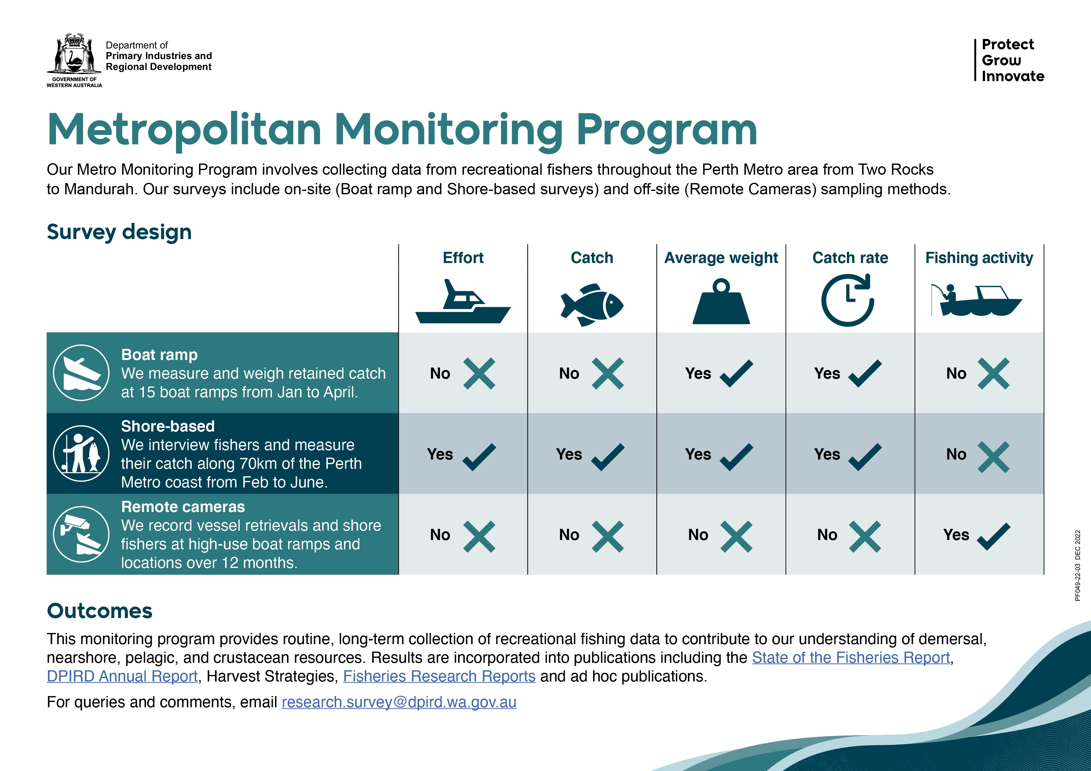
The Metropolitan Monitoring Program streamlines regular and ongoing monitoring of boat- and shore-based recreational fishing primarily within the Metro zone, but also in selected key high-use areas throughout the West Coast bioregion. The objective is to enable routine, long-term data collection to monitor recreational fishing and to inform management decisions.
Three surveys (boat ramp surveys, roving creel surveys and remote cameras) will be completed on an annual basis. All three surveys play an important role in providing information on different aspects of the recreational fishery. These survey methods will be supplemented with data from statewide, off-site phone diary surveys.
Boat ramp survey
In this survey, face-to-face interviews with recreational fishers are completed when they return to the boat ramp at the end of their fishing trip. The boat ramp survey is run annually and provides a measure of average weight and catch rate of species caught by boat-based recreational fishers. This includes nearshore, demersal and pelagic finfish species, as well as crustaceans.
Nine of the boat ramps surveyed are in the Metro zone in the West Coast Bioregion, between Two Rocks and Mandurah. An additional six ramps are also surveyed in the wider West Coast Bioregion (Geraldton, Dongara, Jurien Bay, Bunbury, Busselton and Augusta).
During each survey, Research Survey Officers record the number of people in the fishing party, number and type of gear used, and then measure and weigh any retained catch. We also ask questions to better understand fisher demographics and behaviours, such as the number of times they have fished in the last 12-months (avidity), postcode and age.
This survey uses a restricted spatio-temporal design. That means we target key boat ramps during peak times of fishing activity to maximise the collection of biological information. However, we also incorporate elements of randomisation into the sampling to make sure our data are not biased toward the biggest (or smallest) fishing boat or total catch. We do this by randomly selecting survey days and the fisher that we interview within the fishing party.
This survey design has previously been used to collect data from recreational fishers in our Statewide Survey of Boat-Based Recreational Fishing. Check out the Fisheries Research Report with the latest statewide results
Shore-based (roving creel) survey
In this survey we conduct face-to-face interviews with recreational fishers while they are fishing on beaches, groynes and reef platforms between Ocean Reef and Point Peron. The shore-based survey is run annually and gives us a measure of recreational fishing effort, catch, average weight and catch rate, primarily for nearshore species, but also some demersal species.
In this on-site survey, Research Survey Officers record the size of the fishing party, number and type of gear used, the number of species caught and released, and then measure a random selection of the retained catch.
This survey uses a probability-based, stratified and randomised survey design to collect data. This means that our Research Survey Officers travel along a predetermined route, stopping at each location for a designated wait time, and count the number of active fishers at each site. In addition, randomly selected fishing parties are interviewed. The day type (weekend/public holiday or weekday), time of day, start location and direction of travel are randomised to reduce bias in our data. This means we survey locations at all different times of day – and a beach has a random chance of being completely empty or absolutely packed with fishers.
This survey was previously called the ‘Perth Metropolitan Shore-based Recreational Fishing Survey’. Check out the results from the last survey in the Fisheries Research Report.
Remote cameras
Remote cameras operate 24/7 at 13 key public boat ramps within the Perth Metro area. By counting the number of boat retrievals at a boat ramp, we can find out when the peak times of boating activity are, and measure changes over time. This data also feeds into the planning of our boat ramp surveys to ensure we are scheduling surveys at peak retrieval times.
The Metropolitan Monitoring Program will also count shore-based fishers for a 12-month period using new remote cameras located at high use locations in the survey area. This will help us better understand the patterns of shore fishing within the study area and provide data to information future monitoring.
Our Reports
Boat-based recreational fishing in Western Australia 2020/21
Science Update October 2022
Bioregion summaries
Shore based results
Shore-Based fisheries research report
Metro monitoring survey design